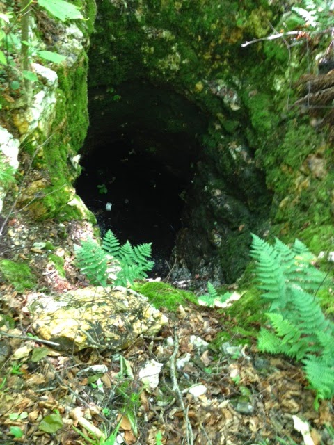
Dave M. recently put in some hiking on Rabbit Hill and found four exploratory vertical "mine shafts" on the hill above the Carpenter farm. There's a bit of sheep fence around one of them -- a discussion in itself -- and water has pooled in most, with deep green water-loving plants all around and even inside them.
When were the shafts excavated? Who did this? What happened to the copper and gold ore from these?
Here are some published items that shed light. First, from
A Vermont Village, our town history by Dr. C. E. Harris:
Mr. Irving Carpenter informed us that in some of his grandfather's papers he came across a number of assay charts of stone and rock from the farm on Rabbit Hill which showed the presence of gold and copper. Mr. Irving said that he showed those charts to an authority on such matters and was assured that the assay of rock from Rabbit Hill showed a greater percentage of gold per ton than did that in the average gold mine of today, but he stated that to get the rock out, to have it smelted and refined would cost more than it would be worth. (pp. 77-78 of original edition, published 1941)
The 1875 Beers map of Waterford doesn't mention the excavations on the Carpenter land (although it shows "copper mines" just outside Upper Waterford). But it does show the landowner of the land where the photographed shafts are as F. R. Carpenter in 1875.
So, a little about F. R. Carpenter: Francis Rice Carpenter, 1809-1883, a farmer and a deacon in the Congregational Church, married Achsah (born about 1812) on December 30, 1835, in Waterford. They had three children listed in the 1860 Census: Elmore A. (b. 1838), Allen T. (b. 1842), and Harlan J. (b. 1846). The 1860 Census also shows that Diantha J. Works, age 10, lived with the family at the time. Francis Rice Carpenter's father's name was Jonah, and Jonah was born in Connecticut, the first of this family to move to Vermont and settle in Waterford.
Now, a little more about the copper in the area: The authoritative work is
The Geology of Littleton, New Hamphire, but C. H. Hitchcock, 1905 -- the author saw the land as continuing across the Connecticut river and makes plenty of mention of Waterford locations as he described the rocks and minerals of the region. On page 21 he writes of copper and says, "Twenty-five or thirty years ago [that would be, say, 1875-1880, some years AFTER the California Gold Rush of 1849] considerable interest was manifested in the exploitation of ores of copper both in Littleton and the adjoining towns." He calls the related rocks "hydro-mica schist" -- in which "schist" means a kind of rock that can be split into layers when you strike it, and mica is that shiny, sparkly material you see sometimes in chunks of sparkly white stone (like the chunks around our Rabbit Hill shafts).
Hitchcock says the copper-related ore, called "chalcopyrite, the common yellow copper sulphuret," contained 34.6 percent copper among the metals in it (the others were "sulphur" -- not really a metal -- at 34.9 percent and iron at 30.5 percent). He adds that "Some of these sulphurets are sparingly auriferous" -- and the prefix "aur" means gold.
The Littleton-area companies that got involved in the copper/gold mining in the 1870s were the Gardner Mountain Copper Company and the Gregory Mining Company. But Hitchcock went on to say, "The copper industry has not proved a success in Littleton, at least the proprietors have ceased to work their properties. A part of the difficulty arises from the fact that the greater deposits of an easier ore to work in Michigan and Montana have lowered the price of the product so that it is not profitable to reduce the refractory sulphuret compounds of the East."
At this point we (the Waterford History interest group that meets at the library) have not yet located the Beers map "copper mines" near Upper Waterford, but ... we will. Check back in for more information another time.