Friday, January 23, 2015

Spring!!! Um, Not Really -- But We Can Meet in Waterford, Vermont, Anyway, Right?

Not too springlike yet, hmm?

Calling all Waterford, Vermont, historians! Tomorrow, Sat Jan 24, from 9 a.m. to noon, pitch in at the Davies Memorial Library as we sort, label, and file the wonderful written and photo materials on hand, creating the first organized archive for Waterford history.

A dream archive ... well, everyone needs a goal ...
And consider attending the February "Waterford History Group" meeting on Wed Feb 25, for a packed agenda of excitement: who made the newest nature trail in town and where is it?; a presentation on the history of Waterford Springs and Copenhagen; real butternuts to try cracking; organizing an official Waterford Historical Society; planning a Town Meeting exhibit and presentation; and more. Meet at 6:30 pm at the library -- for about an hour, with "visiting" afterward.

Saturday, November 1, 2014

Cushman–Russell–Bugbee–McGregor Cemetery, East Village Road, Waterford, Vermont: Small with a Wide Vista


Visiting the Cushman Cemetery is much easier, now that it's been trimmed and mowed -- a late-autumn caretaking gift (it would be nice to know who did this, to thank you!). It's a peaceful little family cemetery at the edge of a cornfield near the end of East Village Road.

This material describing the stones is per UPPERCONNRIVER and given at the website http://freepages.genealogy.rootsweb.ancestry.com/~upperconnriver/Waterford/Cushman/Cushman.htm and I am grateful for permission to share it from the site (but please do check in now and then at the original website to see any changes added).


[I am aware that the town selectboard hopes to replace the earlier fence in order to rehang this nice old gate. -- BK]


Cushman Family Cemetery, East Village Rd,
Waterford, Caledonia County, Vermont, USA

earliest birth recorded in this cemetery: Olive Bugbee b. 1794 - d. 1866
earliest inscription in this cemetery: Almyra, wife of John McGregor b. 1802a - d. Oct 03 1843
most recent burial in this cemetery: Russell Cushman b. 1907 - d. 1980
total inscriptions in this cemetery: 11; total graves: unknown
Transcribed 1980 by Eugenia Powers (1913-1985)
databased 2008 by Robert Goss
verified & corrected 2008
by me [Robert Goss].


          Stones are oriented so as to be readable when facing the surounding stone walls.
          To reach this cemetery, turn off US Rte 2 in East St Johnsbury, cross the river onto East Village Rd (TR#4), bear right at the fork, follow this road about 1.1 mi to the "end". There appears to be a left-curve here, but it is actually TR#5, (TR#4 once continued straight thru Blodgett's mailbox into the trees and down the backside of Moose River into Concord, joining Cross Rd near the old fairground - it is now discontinued). You can see the cemetery to your left across the field; please walk next to the stone wall when the hay [corn] is growing.
          This is a family cemetery that is no longer maintained. It was turned over to the town for maintenance in 1980 as it was no longer convient for the family to care for it.
          Stone #8 appears out-of-place because the burial took place after Eugenia completed her transcript and map.

NOTE:  a slash "/" indicates the end of a line of engraving on the gravestone.
       DOBs followed by an "a" are calculated from the DOD on the stone minus the AGE on the stone.
       italics indicate the info is from other vital or town records; but, not actually on the stone.


Cem+
StoneNum
LastName FirstName Maiden DOB DOD Spouse/Parents Add'l Info
CU+0.1 A white marble stone, 2" above ground, 6" wide, 2" thick, split into two 1" thick pieces - no lettering seen.
CU+0.2 P B A white marble stone, 6" high, 6" wide, 2" thick - like a footstone, initials "B. P.".
CU+1.1 Reed Nichols S. 01/__/1830a 7/15/1855 Aged 25 y'rs 6 mos. White marble with low angle top, square name band, plain, lettering is on the west side facing the back wall, grave is to the east of the stone. Stone is about 5' tall and has been down for years, it was found buried (in 2008) under 3" of thick hay thatch and has weathered so badly that it is barely readable.
CU+1.2 Reed Mariah L. 1/01/1826 10/01/1899 Aged 73 yrs 9 mos. Same as above except square name band has tracery, marble has darkened more, & veins are more pronounced.
CU+1.3a Reed Milo 03/__/1851a 10/15/1851 children of N. S. and M. L. Reed AE 7 mos. 18" high, grayed white marble, square name band, plain.
CU+1.3b Reed Azelia 1/27/1854a 2/16/1854 children of N. S. and M. L. Reed AE 3 weeks. 18" high, grayed white marble, square name band, plain.
CU+2.1 Russell George S. 10/__/1823a 6/08/1910 AE 86 yrs 8 mos. Matches #2.2; six inches thick with wide bevel at top and taper down side. Leaf design on top bevel with an X in the middle (crossed stems??), line tracery on side bevel, curved name band with line tracery background and fancy inside edge, then there is a double size double marble base for both stones. Parents of Mrs. Emma Cushman ?? Alpheus Bugbee settled in this part of town in 1800. Russell and Reeds are Concord and Kirby names.
CU+2.2 Russell Emma L. Bugbee 12/__/1822a 7/04/1908 wife of George S. Russell AE 85 yrs 8 mos. Stone matches #2.1
CU+2.3a Cushman Edgar O. 1854 1925 Gray granite monument with name on the face. Corner rose design, 12" thick, smooth but not polished.
CU+2.3b Cushman Edna L. Russell 1852 1946 his wife {of Edgar O. Cushman]
CU+2.4 McGregor Almyra 10/__/1802a 10/03/1843 wife of John McGregor AE 41 yrs. Two and one half feet high, perfectly plain with square top. All the lettering slants forward, whether cursive or another style, except for her name.
CU+2.5 McGregor John 1800a 08/__/1848 AE 48. Same style except thicker. Straight lettering except verse which is a small script, "How brief is life--how long eternity".
CU+2.6 Bugbee Hannah 1798 8/26/1876 Aged 78 yrs. Heavy very much darkened gray granite markers which may replace original stones, about 15" tall and 20" wide. Pillow shaped with lettering on a somewhat convex face.
CU+2.7 Bugbee Olive 1794 1866 Aged 72 yrs. Stone matches #2.6.
CU+2.8 Cushman Russell B 1907 1980 Modern grass-high, gray granite marker.


Sunday, October 26, 2014

Waterford (Vermont) Sugarhouse: But Which One?

At the Waterford Historical Group meetings (held at the Davies Memorial Library in Lower Waterford), we often find details on the old maps of town that intrigue us. One last summer turned out to be a bit discouraging -- at the time when the 1875 Beers map of the town was drawn, there was an important sugarhouse in the center of Waterford, owned by O. Cushman, on the Duck Pond Road.

It would be great to make a visit to the remains of this sugarhouse, even if it's just a cellar hole or a foundation edge. But, of course, sugarhouses (farm structures!) don't usually have cellars or foundations. And the more we studied the map, the more we all became sure that the location of this old sugarhouse is probably within today's tangle of gravel pits owned by the Town of Waterford and Pike, Inc. In other words, there's probably no trace to find. We'll just have to keep looking in old magazines and newspapers for a possible description of how much maple syrup came from that sugaring operation and whether it was a "destination" for local residents.

Meanwhile, this postcard, clearly labeled "Sugarhouse in Waterford," turned up at a postcard show in New Hampshire last summer. The photo looks recent enough (in full color!) so that this structure might still be standing. Is it the one on County Road North? I think the row of trees is too close to it. What do you think? Can you pinpoint its location? -- UPDATE: Thank you to Dave Morrison, who identified this sugarhouse as the one on the Frank Bullock property -- the landscape has since closed in somewhat around it but it is still standing. SECOND UPDATE: Vermont Life Autumn 1957 cover featured a 1951 photo of the same sugarhouse: click here.

All the details keep adding up to the history of our town.

Friday, October 24, 2014

Power Plant and Business in Neighboring St Johnsbury, Vermont, Circa 1910


This winter, we'll work on more of the details of Waterford's water-powered mills, which ranged from traditional sawmills, to a tannery, and an oil mill (linseed!). And of course, Waterford's 20th and 21st centuries are strongly influenced by the three linked power dams on the Connecticut River (including Moore Dam, the one that most affected the town's history, and Comerford, with its amazing construction in 1928-1930, explored elsewhere on this blog; the third is McIndoes).

So it's a good time to look at this postcard of a power station that still exists, at the confluence of the Moose and Passumpsic Rivers in the next town west, St. Johnsbury. (Click on the images to see them enlarged.) My ever-researching husband Dave dates this postcard at about 1910; the "reverse" treats economic hard times pretty cheerfully! Local residents and dedicated visitors will recognize this mill site, where today's "Old Mill" fitness club and neighboring restaurant prosper. A fishing platform is being installed a short distance downstream, at Fred Mold Park. Changes! But good ones, we hope.

Three cheers for O. V. Hooker and Son, promoting their sturdy business through the power of the press and postcards, a century ago.

Thursday, October 23, 2014

Rocks, Quarries, and Mines: Digging into Waterford's 19th Century

Yesterday evening's well-attended meeting of the Waterford History group was the last scheduled one for this season; we'll resume in February, weather permitting!

Meanwhile, in January, an archiving group will meet to sort out and catalogue the many intriguing documents that people have generously provided to our files. Count on some surprises as we share images and information.

We also hope to host a professional geologist early in 2015, as we need to learn more about the rocks, sand, and "dirt" of our town. This season's exploration of our copper and gold mining past (no fortunes were made!) kept some of us among the ridges and hilltops, but we also have "history" to explore in farm fields and along the river. This area in the 1800s provided wide-ranging resources and commerce. We're also mapping the industries and businesses from that period, with the help of atlases, business registries, and a gazetteer.

One of the longer lasting "extractive" industries in Waterford involved quarrying slate for roofing. (Have you driven along Slate Ledge Road lately?) Here is a double photo (stereo view) of the nearby slate quarry in Littleton, NH, when it was active -- click on the photo to see it better.


Tuesday, October 21, 2014

Lower Waterford: Changes on the Main Road

The postcard above was mailed in 1909. You can see the town was already famous as a destination!

And here's one mailed in 1907:


But today's Lower Waterford Road, even though part of the stage route, was once a country lane, as shown in this postcard mailed in 1912:


Later that year, the inn would close -- part of a long intriguing tale told at the Rabbit Hill Inn website, http://www.rabbithillinn.com/about/inn-history -- and in 1957, it reopened, but as a "motor inn" owned by the St. Johnsbury House. Check out the sign on the roof!


In 1968, Ruth and John Carroll owned the inn, and later, Eric and Beryl Charlton:

Here's a Lower Waterford postcard from the 1990s, courtesy of Dave Kanell:


Today's Rabbit Hill Inn innkeepers are Brian & Leslie Mulcahy, and they will host, on November 2, the annual Apres Foliage Fest, an elegant get-together where the tickets and auction raise funds for the Davies Memorial Library, across the road.


Tuesday, August 26, 2014

Fifteen Mile Falls and Waterford's Dams: A Fragile but Essential Document

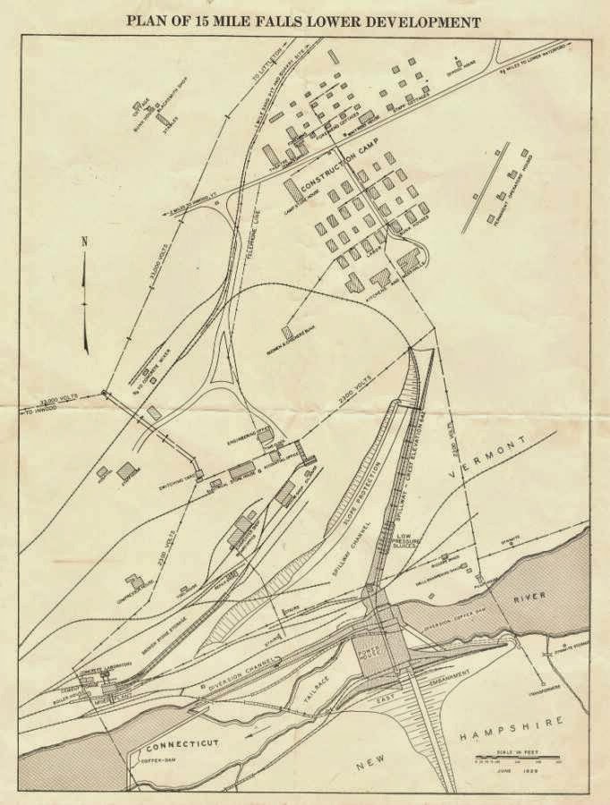
The meeting of the Waterford History group at the Davies Memorial Library on Wed. Aug. 27 (6:30 pm) will focus on how to store and organize the historically interesting items that people bring to the library or keep at home. An example of what we might consider, with our guests Garret Nelson (library director, Lyndon State College) and Marjorie Strong (librarian, Vermont Historical Society) is this four-page document printed on a single sheet of very fragile paper, dating to the years when Comerford Dam was being built. It includes the now-rare map of the "construction camp" and many of the details bring fresh perspective -- like the stables!

The scans shown here were made on a flat-bed scanner, with enormous care, as the document is "tender" at the fold and can't take much handling. How can we best preserve and protect it as information, and as the fragile item it has become?

Hope you'll join the discussion!