At the Waterford Historical Group meetings (held at the Davies Memorial Library in Lower Waterford), we often find details on the old maps of town that intrigue us. One last summer turned out to be a bit discouraging -- at the time when the 1875 Beers map of the town was drawn, there was an important sugarhouse in the center of Waterford, owned by O. Cushman, on the Duck Pond Road.
It would be great to make a visit to the remains of this sugarhouse, even if it's just a cellar hole or a foundation edge. But, of course, sugarhouses (farm structures!) don't usually have cellars or foundations. And the more we studied the map, the more we all became sure that the location of this old sugarhouse is probably within today's tangle of gravel pits owned by the Town of Waterford and Pike, Inc. In other words, there's probably no trace to find. We'll just have to keep looking in old magazines and newspapers for a possible description of how much maple syrup came from that sugaring operation and whether it was a "destination" for local residents.
Meanwhile, this postcard, clearly labeled "Sugarhouse in Waterford," turned up at a postcard show in New Hampshire last summer. The photo looks recent enough (in full color!) so that this structure might still be standing. Is it the one on County Road North? I think the row of trees is too close to it. What do you think? Can you pinpoint its location? -- UPDATE: Thank you to Dave Morrison, who identified this sugarhouse as the one on the Frank Bullock property -- the landscape has since closed in somewhat around it but it is still standing. SECOND UPDATE: Vermont Life Autumn 1957 cover featured a 1951 photo of the same sugarhouse: click here.
All the details keep adding up to the history of our town.
History, old and new, of the Vermont town of Waterford, on the Connecticut River just east of St. Johnsbury.
Sunday, October 26, 2014
Friday, October 24, 2014
Power Plant and Business in Neighboring St Johnsbury, Vermont, Circa 1910
This winter, we'll work on more of the details of Waterford's water-powered mills, which ranged from traditional sawmills, to a tannery, and an oil mill (linseed!). And of course, Waterford's 20th and 21st centuries are strongly influenced by the three linked power dams on the Connecticut River (including Moore Dam, the one that most affected the town's history, and Comerford, with its amazing construction in 1928-1930, explored elsewhere on this blog; the third is McIndoes).
So it's a good time to look at this postcard of a power station that still exists, at the confluence of the Moose and Passumpsic Rivers in the next town west, St. Johnsbury. (Click on the images to see them enlarged.) My ever-researching husband Dave dates this postcard at about 1910; the "reverse" treats economic hard times pretty cheerfully! Local residents and dedicated visitors will recognize this mill site, where today's "Old Mill" fitness club and neighboring restaurant prosper. A fishing platform is being installed a short distance downstream, at Fred Mold Park. Changes! But good ones, we hope.
Three cheers for O. V. Hooker and Son, promoting their sturdy business through the power of the press and postcards, a century ago.
Labels:
Connecticut River,
electrical power,
history,
Moose River,
O. V. Hooker,
Passumpsic River,
postcard,
power dams,
rivers,
St. Johnsbury,
Waterford
Thursday, October 23, 2014
Rocks, Quarries, and Mines: Digging into Waterford's 19th Century
Yesterday evening's well-attended meeting of the Waterford History group was the last scheduled one for this season; we'll resume in February, weather permitting!
Meanwhile, in January, an archiving group will meet to sort out and catalogue the many intriguing documents that people have generously provided to our files. Count on some surprises as we share images and information.
We also hope to host a professional geologist early in 2015, as we need to learn more about the rocks, sand, and "dirt" of our town. This season's exploration of our copper and gold mining past (no fortunes were made!) kept some of us among the ridges and hilltops, but we also have "history" to explore in farm fields and along the river. This area in the 1800s provided wide-ranging resources and commerce. We're also mapping the industries and businesses from that period, with the help of atlases, business registries, and a gazetteer.
One of the longer lasting "extractive" industries in Waterford involved quarrying slate for roofing. (Have you driven along Slate Ledge Road lately?) Here is a double photo (stereo view) of the nearby slate quarry in Littleton, NH, when it was active -- click on the photo to see it better.
Meanwhile, in January, an archiving group will meet to sort out and catalogue the many intriguing documents that people have generously provided to our files. Count on some surprises as we share images and information.
We also hope to host a professional geologist early in 2015, as we need to learn more about the rocks, sand, and "dirt" of our town. This season's exploration of our copper and gold mining past (no fortunes were made!) kept some of us among the ridges and hilltops, but we also have "history" to explore in farm fields and along the river. This area in the 1800s provided wide-ranging resources and commerce. We're also mapping the industries and businesses from that period, with the help of atlases, business registries, and a gazetteer.
One of the longer lasting "extractive" industries in Waterford involved quarrying slate for roofing. (Have you driven along Slate Ledge Road lately?) Here is a double photo (stereo view) of the nearby slate quarry in Littleton, NH, when it was active -- click on the photo to see it better.
Tuesday, October 21, 2014
Lower Waterford: Changes on the Main Road
The postcard above was mailed in 1909. You can see the town was already famous as a destination!
And here's one mailed in 1907:
But today's Lower Waterford Road, even though part of the stage route, was once a country lane, as shown in this postcard mailed in 1912:
Later that year, the inn would close -- part of a long intriguing tale told at the Rabbit Hill Inn website, http://www.rabbithillinn.com/about/inn-history -- and in 1957, it reopened, but as a "motor inn" owned by the St. Johnsbury House. Check out the sign on the roof!
In 1968, Ruth and John Carroll owned the inn, and later, Eric and Beryl Charlton:
Here's a Lower Waterford postcard from the 1990s, courtesy of Dave Kanell:
Today's Rabbit Hill Inn innkeepers are Brian & Leslie Mulcahy, and they will host, on November 2, the annual Apres Foliage Fest, an elegant get-together where the tickets and auction raise funds for the Davies Memorial Library, across the road.
And here's one mailed in 1907:
But today's Lower Waterford Road, even though part of the stage route, was once a country lane, as shown in this postcard mailed in 1912:
Later that year, the inn would close -- part of a long intriguing tale told at the Rabbit Hill Inn website, http://www.rabbithillinn.com/about/inn-history -- and in 1957, it reopened, but as a "motor inn" owned by the St. Johnsbury House. Check out the sign on the roof!
In 1968, Ruth and John Carroll owned the inn, and later, Eric and Beryl Charlton:
Here's a Lower Waterford postcard from the 1990s, courtesy of Dave Kanell:
Today's Rabbit Hill Inn innkeepers are Brian & Leslie Mulcahy, and they will host, on November 2, the annual Apres Foliage Fest, an elegant get-together where the tickets and auction raise funds for the Davies Memorial Library, across the road.
Labels:
1900s,
history,
Lower Waterford,
Rabbit Hill Inn,
Vermont,
Waterford
Tuesday, August 26, 2014
Fifteen Mile Falls and Waterford's Dams: A Fragile but Essential Document
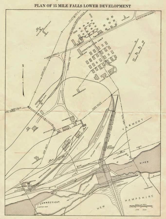
The meeting of the Waterford History group at the Davies Memorial Library on Wed. Aug. 27 (6:30 pm) will focus on how to store and organize the historically interesting items that people bring to the library or keep at home. An example of what we might consider, with our guests Garret Nelson (library director, Lyndon State College) and Marjorie Strong (librarian, Vermont Historical Society) is this four-page document printed on a single sheet of very fragile paper, dating to the years when Comerford Dam was being built. It includes the now-rare map of the "construction camp" and many of the details bring fresh perspective -- like the stables!
The scans shown here were made on a flat-bed scanner, with enormous care, as the document is "tender" at the fold and can't take much handling. How can we best preserve and protect it as information, and as the fragile item it has become?
Hope you'll join the discussion!
The scans shown here were made on a flat-bed scanner, with enormous care, as the document is "tender" at the fold and can't take much handling. How can we best preserve and protect it as information, and as the fragile item it has become?
Hope you'll join the discussion!
Labels:
15 Mile Falls,
archives,
Comerford Dam,
documents,
Fifteen Mile Falls,
guest speakers,
Vermont,
Waterford,
Waterford History Group
Sunday, August 17, 2014
Recipes from Waterford's Earlier Years
![]() |
| Apple cranberry crisp. |
My contribution was a half gallon of the old-time haymakers' thirst quencher known as switchel. I used a recipe from a collection of traditional Vermont cooks, adapting it to include maple syrup, which I've often heard as an ingredient in this drink, although the original wasn't written for it. Here's the switchel recipe, from the "Vermont Grange Favorites," modified the way I made it for the Barn-to-Table event:
SWITCHEL
2/3 cup brown sugar
1 cup cider vinegar
1/3 cup molasses
1/2 cup maple syrup
1 teaspoon ground ginger
Put all ingredients into a two-quart pitcher, Add cold water to make two quarts and stir well. Chill.
***
While we're on the topic of earlier recipes, Waterford has two cookbook collections of these, with the more recent one being a fundraiser for the fire department. For our July get-together, I baked
BLUEBERRY BUCKLE CAKE from Laura Goodwin’s recipe in the
fire department cookbook.
Doing this reminded me to look up, again, the differences among the various fruit dessert terms that were common a century ago, and even a generation ago. We're headed to apple crisp next, right? Or apple pan dowdy? Or apple brown betty? How many have you baked?
Here are some definitions of those dessert names (with thanks for some tips from baking pro Carol Pellegrinelli):
BUCKLE: Buckles
are baked and are usually made in one or two ways. The first way is that bottom
layer is cake-like with the berries mixed in (as in Laura’s recipe). Then the
top layer is crumb-like. The second way is where the cake layer is on the
bottom of the pan, the berries are the next layer and the top is the crumble
mixture. Blueberry Buckle is the most prevalent Buckle recipe found.
COBBLER:
The fruit filling is put in a deep baking dish and topped with a biscuit dough.
The dough may completely cover the fruit or it may just be dropped in handfuls.
Either way, a cobbler is baked.
CRISP:
In this baked dessert, the fruit filling is covered with a crunchy topping that
is crumbled over the top. (Similar: the CRUMBLE, in which the topping is
crumbled on top.)
GRUNT: A
grunt is a stewed or baked fruit dish. Biscuit dough is rolled and put on top
of the fruit. The name of grunt may have come from the noise people made while
eating it. Grunts are also known as slumps.
PAN
DOWDY or PANDOWDY: You'll find both spellings in this baked dish. The dough is
on top of the fruit and although it is rolled out, it ends up being crumbly.
SLUMP:
Same as grunt.
BROWN
BETTY: Traditional baked American dessert made from fruit (usually apples, but
also berries or pears) and sweetend crumbs, which are in layers between the
fruit. Dates back to at least 1864, and an 1877 recipe uses apple sauce and
cracker crumbs. Also known as one of the favorite desserts of Pres. and Mrs.
Reagan in the White House.
Saturday, August 16, 2014
Fifteen-Mile Falls Turns to Hydro Power: Two Promotional Documents
The New England Power Association, like many Waterford, Vermont, residents, took great pride in the completion of Comerford Dam, which began generating power in 1930. Here are two promotional documents that the company provided.
| 1930 |
| 1931 |
Subscribe to:
Posts (Atom)