Saturday, November 1, 2014

Cushman–Russell–Bugbee–McGregor Cemetery, East Village Road, Waterford, Vermont: Small with a Wide Vista


Visiting the Cushman Cemetery is much easier, now that it's been trimmed and mowed -- a late-autumn caretaking gift (it would be nice to know who did this, to thank you!). It's a peaceful little family cemetery at the edge of a cornfield near the end of East Village Road.

This material describing the stones is per UPPERCONNRIVER and given at the website http://freepages.genealogy.rootsweb.ancestry.com/~upperconnriver/Waterford/Cushman/Cushman.htm and I am grateful for permission to share it from the site (but please do check in now and then at the original website to see any changes added).


[I am aware that the town selectboard hopes to replace the earlier fence in order to rehang this nice old gate. -- BK]


Cushman Family Cemetery, East Village Rd,
Waterford, Caledonia County, Vermont, USA

earliest birth recorded in this cemetery: Olive Bugbee b. 1794 - d. 1866
earliest inscription in this cemetery: Almyra, wife of John McGregor b. 1802a - d. Oct 03 1843
most recent burial in this cemetery: Russell Cushman b. 1907 - d. 1980
total inscriptions in this cemetery: 11; total graves: unknown
Transcribed 1980 by Eugenia Powers (1913-1985)
databased 2008 by Robert Goss
verified & corrected 2008
by me [Robert Goss].


          Stones are oriented so as to be readable when facing the surounding stone walls.
          To reach this cemetery, turn off US Rte 2 in East St Johnsbury, cross the river onto East Village Rd (TR#4), bear right at the fork, follow this road about 1.1 mi to the "end". There appears to be a left-curve here, but it is actually TR#5, (TR#4 once continued straight thru Blodgett's mailbox into the trees and down the backside of Moose River into Concord, joining Cross Rd near the old fairground - it is now discontinued). You can see the cemetery to your left across the field; please walk next to the stone wall when the hay [corn] is growing.
          This is a family cemetery that is no longer maintained. It was turned over to the town for maintenance in 1980 as it was no longer convient for the family to care for it.
          Stone #8 appears out-of-place because the burial took place after Eugenia completed her transcript and map.

NOTE:  a slash "/" indicates the end of a line of engraving on the gravestone.
       DOBs followed by an "a" are calculated from the DOD on the stone minus the AGE on the stone.
       italics indicate the info is from other vital or town records; but, not actually on the stone.


Cem+
StoneNum
LastName FirstName Maiden DOB DOD Spouse/Parents Add'l Info
CU+0.1 A white marble stone, 2" above ground, 6" wide, 2" thick, split into two 1" thick pieces - no lettering seen.
CU+0.2 P B A white marble stone, 6" high, 6" wide, 2" thick - like a footstone, initials "B. P.".
CU+1.1 Reed Nichols S. 01/__/1830a 7/15/1855 Aged 25 y'rs 6 mos. White marble with low angle top, square name band, plain, lettering is on the west side facing the back wall, grave is to the east of the stone. Stone is about 5' tall and has been down for years, it was found buried (in 2008) under 3" of thick hay thatch and has weathered so badly that it is barely readable.
CU+1.2 Reed Mariah L. 1/01/1826 10/01/1899 Aged 73 yrs 9 mos. Same as above except square name band has tracery, marble has darkened more, & veins are more pronounced.
CU+1.3a Reed Milo 03/__/1851a 10/15/1851 children of N. S. and M. L. Reed AE 7 mos. 18" high, grayed white marble, square name band, plain.
CU+1.3b Reed Azelia 1/27/1854a 2/16/1854 children of N. S. and M. L. Reed AE 3 weeks. 18" high, grayed white marble, square name band, plain.
CU+2.1 Russell George S. 10/__/1823a 6/08/1910 AE 86 yrs 8 mos. Matches #2.2; six inches thick with wide bevel at top and taper down side. Leaf design on top bevel with an X in the middle (crossed stems??), line tracery on side bevel, curved name band with line tracery background and fancy inside edge, then there is a double size double marble base for both stones. Parents of Mrs. Emma Cushman ?? Alpheus Bugbee settled in this part of town in 1800. Russell and Reeds are Concord and Kirby names.
CU+2.2 Russell Emma L. Bugbee 12/__/1822a 7/04/1908 wife of George S. Russell AE 85 yrs 8 mos. Stone matches #2.1
CU+2.3a Cushman Edgar O. 1854 1925 Gray granite monument with name on the face. Corner rose design, 12" thick, smooth but not polished.
CU+2.3b Cushman Edna L. Russell 1852 1946 his wife {of Edgar O. Cushman]
CU+2.4 McGregor Almyra 10/__/1802a 10/03/1843 wife of John McGregor AE 41 yrs. Two and one half feet high, perfectly plain with square top. All the lettering slants forward, whether cursive or another style, except for her name.
CU+2.5 McGregor John 1800a 08/__/1848 AE 48. Same style except thicker. Straight lettering except verse which is a small script, "How brief is life--how long eternity".
CU+2.6 Bugbee Hannah 1798 8/26/1876 Aged 78 yrs. Heavy very much darkened gray granite markers which may replace original stones, about 15" tall and 20" wide. Pillow shaped with lettering on a somewhat convex face.
CU+2.7 Bugbee Olive 1794 1866 Aged 72 yrs. Stone matches #2.6.
CU+2.8 Cushman Russell B 1907 1980 Modern grass-high, gray granite marker.


Sunday, October 26, 2014

Waterford (Vermont) Sugarhouse: But Which One?

At the Waterford Historical Group meetings (held at the Davies Memorial Library in Lower Waterford), we often find details on the old maps of town that intrigue us. One last summer turned out to be a bit discouraging -- at the time when the 1875 Beers map of the town was drawn, there was an important sugarhouse in the center of Waterford, owned by O. Cushman, on the Duck Pond Road.

It would be great to make a visit to the remains of this sugarhouse, even if it's just a cellar hole or a foundation edge. But, of course, sugarhouses (farm structures!) don't usually have cellars or foundations. And the more we studied the map, the more we all became sure that the location of this old sugarhouse is probably within today's tangle of gravel pits owned by the Town of Waterford and Pike, Inc. In other words, there's probably no trace to find. We'll just have to keep looking in old magazines and newspapers for a possible description of how much maple syrup came from that sugaring operation and whether it was a "destination" for local residents.

Meanwhile, this postcard, clearly labeled "Sugarhouse in Waterford," turned up at a postcard show in New Hampshire last summer. The photo looks recent enough (in full color!) so that this structure might still be standing. Is it the one on County Road North? I think the row of trees is too close to it. What do you think? Can you pinpoint its location? -- UPDATE: Thank you to Dave Morrison, who identified this sugarhouse as the one on the Frank Bullock property -- the landscape has since closed in somewhat around it but it is still standing. SECOND UPDATE: Vermont Life Autumn 1957 cover featured a 1951 photo of the same sugarhouse: click here.

All the details keep adding up to the history of our town.

Friday, October 24, 2014

Power Plant and Business in Neighboring St Johnsbury, Vermont, Circa 1910


This winter, we'll work on more of the details of Waterford's water-powered mills, which ranged from traditional sawmills, to a tannery, and an oil mill (linseed!). And of course, Waterford's 20th and 21st centuries are strongly influenced by the three linked power dams on the Connecticut River (including Moore Dam, the one that most affected the town's history, and Comerford, with its amazing construction in 1928-1930, explored elsewhere on this blog; the third is McIndoes).

So it's a good time to look at this postcard of a power station that still exists, at the confluence of the Moose and Passumpsic Rivers in the next town west, St. Johnsbury. (Click on the images to see them enlarged.) My ever-researching husband Dave dates this postcard at about 1910; the "reverse" treats economic hard times pretty cheerfully! Local residents and dedicated visitors will recognize this mill site, where today's "Old Mill" fitness club and neighboring restaurant prosper. A fishing platform is being installed a short distance downstream, at Fred Mold Park. Changes! But good ones, we hope.

Three cheers for O. V. Hooker and Son, promoting their sturdy business through the power of the press and postcards, a century ago.

Thursday, October 23, 2014

Rocks, Quarries, and Mines: Digging into Waterford's 19th Century

Yesterday evening's well-attended meeting of the Waterford History group was the last scheduled one for this season; we'll resume in February, weather permitting!

Meanwhile, in January, an archiving group will meet to sort out and catalogue the many intriguing documents that people have generously provided to our files. Count on some surprises as we share images and information.

We also hope to host a professional geologist early in 2015, as we need to learn more about the rocks, sand, and "dirt" of our town. This season's exploration of our copper and gold mining past (no fortunes were made!) kept some of us among the ridges and hilltops, but we also have "history" to explore in farm fields and along the river. This area in the 1800s provided wide-ranging resources and commerce. We're also mapping the industries and businesses from that period, with the help of atlases, business registries, and a gazetteer.

One of the longer lasting "extractive" industries in Waterford involved quarrying slate for roofing. (Have you driven along Slate Ledge Road lately?) Here is a double photo (stereo view) of the nearby slate quarry in Littleton, NH, when it was active -- click on the photo to see it better.


Tuesday, October 21, 2014

Lower Waterford: Changes on the Main Road

The postcard above was mailed in 1909. You can see the town was already famous as a destination!

And here's one mailed in 1907:


But today's Lower Waterford Road, even though part of the stage route, was once a country lane, as shown in this postcard mailed in 1912:


Later that year, the inn would close -- part of a long intriguing tale told at the Rabbit Hill Inn website, http://www.rabbithillinn.com/about/inn-history -- and in 1957, it reopened, but as a "motor inn" owned by the St. Johnsbury House. Check out the sign on the roof!


In 1968, Ruth and John Carroll owned the inn, and later, Eric and Beryl Charlton:

Here's a Lower Waterford postcard from the 1990s, courtesy of Dave Kanell:


Today's Rabbit Hill Inn innkeepers are Brian & Leslie Mulcahy, and they will host, on November 2, the annual Apres Foliage Fest, an elegant get-together where the tickets and auction raise funds for the Davies Memorial Library, across the road.


Tuesday, August 26, 2014

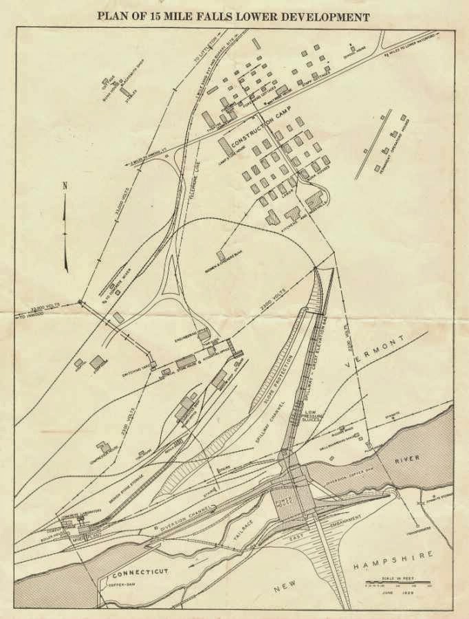
Fifteen Mile Falls and Waterford's Dams: A Fragile but Essential Document

The meeting of the Waterford History group at the Davies Memorial Library on Wed. Aug. 27 (6:30 pm) will focus on how to store and organize the historically interesting items that people bring to the library or keep at home. An example of what we might consider, with our guests Garret Nelson (library director, Lyndon State College) and Marjorie Strong (librarian, Vermont Historical Society) is this four-page document printed on a single sheet of very fragile paper, dating to the years when Comerford Dam was being built. It includes the now-rare map of the "construction camp" and many of the details bring fresh perspective -- like the stables!

The scans shown here were made on a flat-bed scanner, with enormous care, as the document is "tender" at the fold and can't take much handling. How can we best preserve and protect it as information, and as the fragile item it has become?

Hope you'll join the discussion!


Sunday, August 17, 2014

Recipes from Waterford's Earlier Years

Apple cranberry crisp.
The amazing Barn-to-Table event held at the Waterford church this past June, as a co-benefit for the church and the library's Waterford History interest group, served a capacity crowd of 80 people with delicious tastes of recipes connected with the barns that the history group is documenting for the town. Organizer Helen Chantal Pike saw clearly that people can enjoy learning while tasting!

My contribution was a half gallon of the old-time haymakers' thirst quencher known as switchel. I used a recipe from a collection of traditional Vermont cooks, adapting it to include maple syrup, which I've often heard as an ingredient in this drink, although the original wasn't written for it. Here's the switchel recipe, from the "Vermont Grange Favorites," modified the way I made it for the Barn-to-Table event:

SWITCHEL

2/3 cup brown sugar
1 cup cider vinegar
1/3 cup molasses
1/2 cup maple syrup
1 teaspoon ground ginger

Put all ingredients into a two-quart pitcher, Add cold water to make two quarts and stir well. Chill.

***
While we're on the topic of earlier recipes, Waterford has two cookbook collections of these, with the more recent one being a fundraiser for the fire department. For our July get-together, I baked 
BLUEBERRY BUCKLE CAKE from Laura Goodwin’s recipe in the fire department cookbook.

Doing this reminded me to look up, again, the differences among the various fruit dessert terms that were common a century ago, and even a generation ago. We're headed to apple crisp next, right? Or apple pan dowdy? Or apple brown betty? How many have you baked?

Here are some definitions of those dessert names (with thanks for some tips from baking pro Carol Pellegrinelli):

BUCKLE: Buckles are baked and are usually made in one or two ways. The first way is that bottom layer is cake-like with the berries mixed in (as in Laura’s recipe). Then the top layer is crumb-like. The second way is where the cake layer is on the bottom of the pan, the berries are the next layer and the top is the crumble mixture. Blueberry Buckle is the most prevalent Buckle recipe found.

COBBLER: The fruit filling is put in a deep baking dish and topped with a biscuit dough. The dough may completely cover the fruit or it may just be dropped in handfuls. Either way, a cobbler is baked.

CRISP: In this baked dessert, the fruit filling is covered with a crunchy topping that is crumbled over the top. (Similar: the CRUMBLE, in which the topping is crumbled on top.)

GRUNT: A grunt is a stewed or baked fruit dish. Biscuit dough is rolled and put on top of the fruit. The name of grunt may have come from the noise people made while eating it. Grunts are also known as slumps.

PAN DOWDY or PANDOWDY: You'll find both spellings in this baked dish. The dough is on top of the fruit and although it is rolled out, it ends up being crumbly.

SLUMP: Same as grunt.

BROWN BETTY: Traditional baked American dessert made from fruit (usually apples, but also berries or pears) and sweetend crumbs, which are in layers between the fruit. Dates back to at least 1864, and an 1877 recipe uses apple sauce and cracker crumbs. Also known as one of the favorite desserts of Pres. and Mrs. Reagan in the White House.

Saturday, August 16, 2014

Fifteen-Mile Falls Turns to Hydro Power: Two Promotional Documents

The New England Power Association, like many Waterford, Vermont, residents, took great pride in the completion of Comerford Dam, which began generating power in 1930. Here are two promotional documents that the company provided.

1930

1931

Friday, August 15, 2014

A Little History of the White Village

Classic postcard view of the White Village.
from the June 1919 issue of The Ice Cream Trade Journal
Some Notes on THE WHITE VILLAGE, from Beth Kanell

Dr. Harris's history of Waterford uses a Burlington Free Press article from 1937 to explain the history of Lower Waterford's "White Village." At that time -- shortly after the Great Depression, and only a few years before the Second World War -- the town's focus was almost entirely on farming and the trades that go with it, and Upper Waterford still stood up the river from Lower Waterford. Owners of property in the upper village knew that the second major dam on the Connecticut River would flood out their homes and farms, and they were gradually selling land to the New England Power Company in preparation.

The Free Press article described the lower village at that time as almost entirely a summer place "of the better kind where the summer people stay all season and contribute largely to the life of the community." Sometime after 1919, Mr. John W. Davies, a St. Johnsbury creamery owner and originally from Reading, Mass., purchased almost "the entire village" and established its color theme, the one it's still known for: white-painted structures with green shutters. The attractive appearance quickly became a tourist draw.

When Mr. Davies died, many of his buildings were sold, and his wife continued to reside in what's now the famous Rabbit Hill Inn -- but from 1912 to 1957 was a residence. (There's a detailed history of the inn here.) The Rabbit Hill Inn grew from a 1957 purchase that turned the structure first into a "motel," then in 1980, with fresh owners, into a gracious country inn that continued to rise in esteem and elegance as owners built on its possibilities.

On the same side of the road as the inn are a former village store that in the early 1900s housed the library, and also one of the town's early schoolhouses, the Lower Waterford School, now a private home. Across from the inn stands the Congregational Church, as well as the current library -- named for Mr. and Mrs. Davies (the Davies Memorial Library). Around the corner, using a separate entrance to the lower floor of the library building, is the town office and a limited-hours post office that still serves the village.

The color scheme that Mr. Davies initiated remains in place: The White Village is one of the most photographed locations along the Vermont side of the Connecticut River, and is worth visiting in all seasons, to savor both its changes and its enduring gracious character.

***
A little extra information on Mr. Davies: He was born John Wesley Davies in Union, Maine, on July 10, 1866; he married Marion Florence Lombard in Massachusetts on December 26, 1887. They had three children. Mr. Davies died in 1937 in Lower Waterford, where his wife continued to reside until her own death in 1949. In 1930 Mr. Davies was president of the Manton-Gaulin Mfg Co., in St. Johnsbury, a company with considerable expertise and patents in homogenizing milk and making ice cream; Dr. Harris's book suggests that Mr. Davies owned at least two creameries himself, one in St. Johnsbury, VT, and the other in Littleton, NH. -- BK

Saturday, August 9, 2014

Fifteen-Mile Falls and Comerford Dam: Then and Now

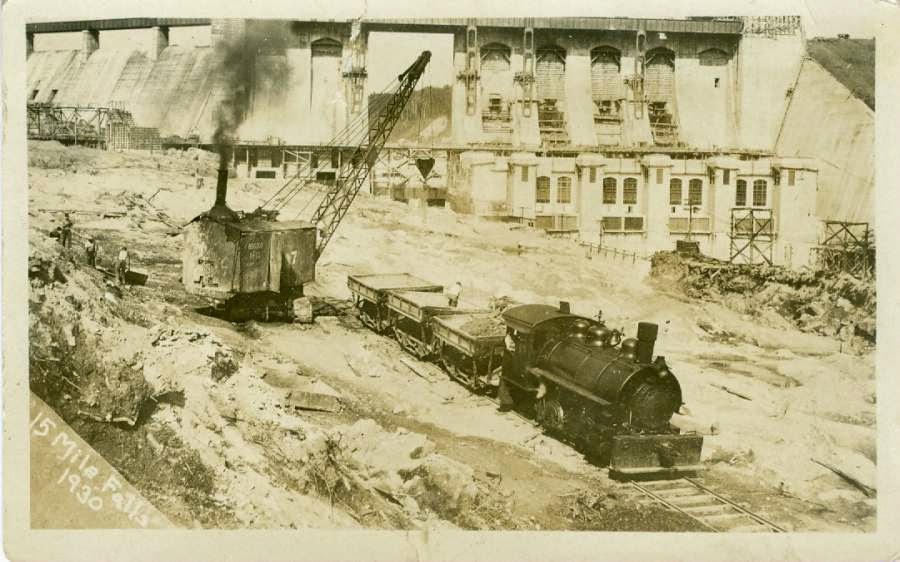
The Waterford History group met Matt Lewis at the TransCanada garage parking lot on the Comerford Dam Road (the Barnet end of Lower Waterford Road) this morning to learn about uses of the area during the construction of the famous Connecticut River dam, starting in 1928 and set into action (by President Hoover, via remote switch) in September 1930.

The construction project required its own rail spur from East Barnet to the dam, and two thousand people or more -- of whom about 1700 lived at the construction site during those years -- took part in building the dam. For a few months, it was actually the largest power-generating dam in the United States (until the Hoover Dam went online). Our meeting and walk, planned and supported by Matt with plenty of maps, blueprint copies, and 1930s documents, reviewed where the "camp" of workers had stood.

Thanks to Matt's planning, we also were able to visit and enter the last standing cabin from those days (now a storage shed and home to many bats). Matt pointed out where the concrete works had been, as well as the original site of the high-voltage service segment of the dam that is now located across the river in New Hampshire. He also noted for us the old road toward the now-water-covered Waterford hamlet of Copenhagen; group members who live in the Waterford Springs part of town were already somewhat familiar with this route. Craig B. shared a photo of the Copenhagen district schoolhouse; Dr. C. E. Harris's history of town also says there was a sawmill in Copenhagen.


Other topics during and after the hike included when the planning for the dams that would cover Fifteen-Mile Falls began. Here is a snippet from Electrical World, October 21, 1909 (p. 1009):
LITTLETON, N. H.—Carl A. Ross, promoter of the power project at Fifteen-Mile Falls, on the Connecticut River, is reported to have sold his interests to Massachusetts capitalists, who are already making plans for the development of three large power plants, by which it is estimated that about 5000 hp would be generated. It is understood that work will commence on the plant next spring. Carl A. Ross will have charge of the project.

Plans for upcoming Waterford History meetings: August, guest speakers Garret Nelson (Lyndon State College library director) and Marjorie Strong (Vermont Historical Society librarian). September, pulling together our archives; there are also plans for a display of pre-archaeology materials at the library at the end of September.  October, geology of the region, with possible guest geologist. November-January, winter break. February, consolidating information about Copenhagen.

Wednesday, July 23, 2014

Gold! Copper! In Waterford? Yes!!


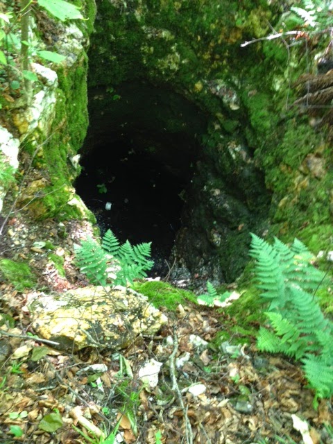
Dave M. recently put in some hiking on Rabbit Hill and found four exploratory vertical "mine shafts" on the hill above the Carpenter farm. There's a bit of sheep fence around one of them -- a discussion in itself -- and water has pooled in most, with deep green water-loving plants all around and even inside them.

When were the shafts excavated? Who did this? What happened to the copper and gold ore from these?

Here are some published items that shed light. First, from A Vermont Village, our town history by Dr. C. E. Harris:
Mr. Irving Carpenter informed us that in some of his grandfather's papers he came across a number of assay charts of stone and rock from the farm on Rabbit Hill which showed the presence of gold and copper. Mr. Irving said that he showed those charts to an authority on such matters and was assured that the assay of rock from Rabbit Hill showed a greater percentage of gold per ton than did that in the average gold mine of today, but he stated that to get the rock out, to have it smelted and refined would cost more than it would be worth. (pp. 77-78 of original edition, published 1941)
The 1875 Beers map of Waterford doesn't mention the excavations on the Carpenter land (although it shows "copper mines" just outside Upper Waterford). But it does show the landowner of the land where the photographed shafts are as F. R. Carpenter in 1875.

So, a little about F. R. Carpenter: Francis Rice Carpenter, 1809-1883, a farmer and a deacon in the Congregational Church, married Achsah (born about 1812) on December 30, 1835, in Waterford. They had three children listed in the 1860 Census: Elmore A. (b. 1838), Allen T. (b. 1842), and Harlan J. (b. 1846). The 1860 Census also shows that Diantha J. Works, age 10, lived with the family at the time. Francis Rice Carpenter's father's name was Jonah, and Jonah was born in Connecticut, the first of this family to move to Vermont and settle in Waterford.

Now, a little more about the copper in the area: The authoritative work is The Geology of Littleton, New Hamphire, but C. H. Hitchcock, 1905 -- the author saw the land as continuing across the Connecticut river and makes plenty of mention of Waterford locations as he described the rocks and minerals of the region. On page 21 he writes of copper and says, "Twenty-five or thirty years ago [that would be, say, 1875-1880, some years AFTER the California Gold Rush of 1849] considerable interest was manifested in the exploitation of ores of copper both in Littleton and the adjoining towns." He calls the related rocks "hydro-mica schist" -- in which "schist" means a kind of rock that can be split into layers when you strike it, and mica is that shiny, sparkly material you see sometimes in chunks of sparkly white stone (like the chunks around our Rabbit Hill shafts).

Hitchcock says the copper-related ore, called "chalcopyrite, the common yellow copper sulphuret," contained 34.6 percent copper among the metals in it (the others were "sulphur" -- not really a metal -- at 34.9 percent and iron at 30.5 percent). He adds that "Some of these sulphurets are sparingly auriferous" -- and the prefix "aur" means gold.

The Littleton-area companies that got involved in the copper/gold mining in the 1870s were the Gardner Mountain Copper Company and the Gregory Mining Company. But Hitchcock went on to say, "The copper industry has not proved a success in Littleton, at least the proprietors have ceased to work their properties. A part of the difficulty arises from the fact that the greater deposits of an easier ore to work in Michigan and Montana have lowered the price of the product so that it is not profitable to reduce the refractory sulphuret compounds of the East."

At this point we (the Waterford History interest group that meets at the library) have not yet located the Beers map "copper mines" near Upper Waterford, but ... we will. Check back in for more information another time.

Saturday, June 7, 2014

Waterford's Own Website: Thanks, Mike Barrett and Kevin Fontecha

http://www.waterfordvt.org

What a gorgeous website Mike and Kevin have provided, to kick off a wonderful summer in Waterford, Vermont! Consider this the "soft opening" of the site -- it's live, but more parts will be added, including a link to this Waterford History site.

Terrific to have town resources available this way; a big thank you to all the town employees who are also participating in this.

Tuesday, June 3, 2014

Making Hay, Part 1 -- Farming in Waterford

Keeping machinery in use at the Gingue Farm, Waterford.
Making and storing hay take up a lot of the summer for Waterford farmers, as they have since the first settlers in the town. As a general summary, haymaking has had three stages: coping with loose hay (even cut by hand scythes at the start), managing "square" (actually mostly rectangular) bales of hay, and moving to the big white "marshmallows" that are plastic-wrapped versions of "big bales" where the wrapping encourages the interior cut grass to ferment, raising its protein level. ("Big bales" can also be used without plastic overwraps -- the outer layer of the bale becomes the hardened protective "wrap" on its own.)

And now haying seems to have come full circle, as many large dairy farms like Waterford's Gingue Farm harvest the tall grass and transport it, somewhat dried and loose, to silos and other forms of storage -- again, to encourage a higher protein level, which helps cows produce more milk.

Gingue Brothers Dairy recently described this newest process on their Facebook page. Not only is it a way to use machines to their best advantage, but it's also a form of coping with a changing climate:
With these short weather windows it's very difficult to make dry hay at 85-90% dry matter (10-15% moisture.) We make some dry hay every year but seems that mama nature only gives us a couple good weeks of dry weather each year. When we make chopped silage and ferment it in the bunk, we dry the grass to 30-40% dry matter (60-70% moisture) this allows us to chop most of the fields the same day they were mowed. We've been planting more cover crops, no-till planting, and using minimal tillage on the rest of our acres to reduce erosion. It's not easy but we are constantly tweaking our crop planning ad practices to help the environment.
So here's a pictorial look at how hay was made a hundred years ago -- when it was cut loose, dried in the field (weather permitting!), and moved to the upper levels of the barn for storage in the "hay mow" until feeding to the cows.

1. Hay loader. This photo is from New Jersey, but I bought it from a Vermonter who said this was how he loaded hay here from the field to the wagons right after World War II, that is, 1945. We talked about these -- with Willard P. and Dave M. speaking from experience -- at the May meeting of the Waterford History group.


2. Hay forks. These chain-operated "giant tongs" could grasp an astounding amount of the wagonload of hay at once. They were attached to a hoist and track up inside the barn roof. From inside the barn, the crew pulled by hand, by horse, and by machine, to lift the hay from the wagon sitting outside, raise it to the door in the upper floor of the barn, and maneuver it to the particular place in the hay mow for storage. Quick and effective!


3. Barn adjustment for hay forks. Waterford farmers mostly cobbled the fork tracks into their existing barns. But in some nearby towns, barns being built during this mechanical lifting period added a projecting "tooth" at the top of the barn roof (gable roofs), so the hoist for the hay fork could rise straight up from the wagon before being pulled into the upper level of the barn with its load. This photo is from Vermonter Thomas Visser's Field Guide to New England Barns and Farm Buildings.