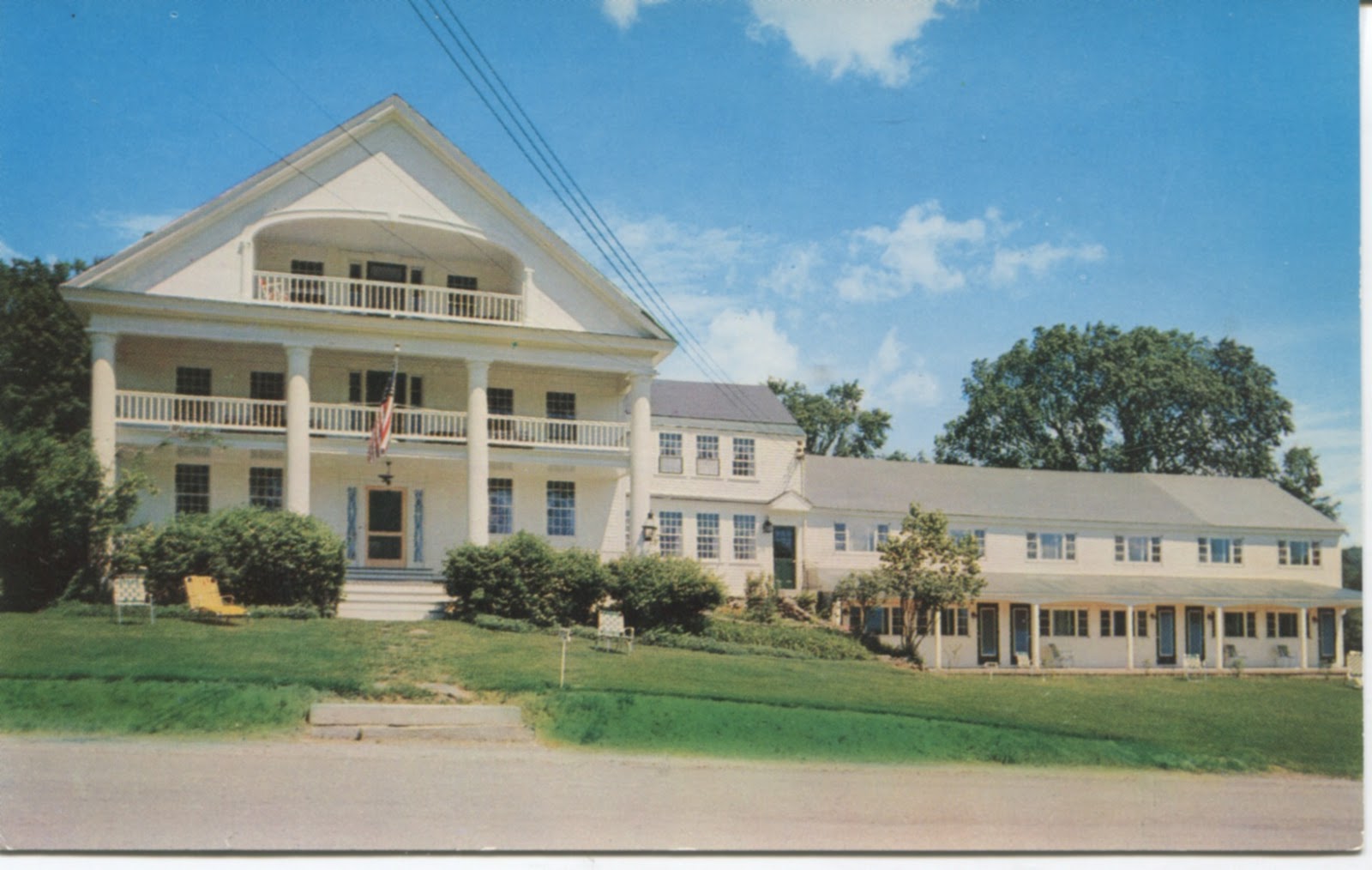
Facebook, Pinterest, and Twitter are the social media that have replaced photo postcards today - but these rectangles of stiffened paper last much longer! Here is an image, printed in the 1950s, of the "Rabbit Hill Motor Inn" in Lower Waterford. The photo was captured by Jenks Studio of St. Johnsbury, Vermont.
By dint of its age, the postcard is now an "antique." What should we be printing to make sure that today's lovely moments are captured for viewers 50 years from now?
History, old and new, of the Vermont town of Waterford, on the Connecticut River just east of St. Johnsbury.
Tuesday, August 18, 2015
A Call for Modern Photo Postcards
Labels:
history,
Lower Waterford,
postcard,
Rabbit Hill Inn,
Vermont
Monday, August 17, 2015
Comerford Dam: Another Early Postcard View
Hard to tell whether the photo was gently enhanced to emphasize the European "Romantic" appearance of the Comerford dam in this postcard, probably printed in the 1930s.
Sunday, August 9, 2015
A Sense of Place: Vermont Farms, Gregory Sharrow
![]() |
| Gregory Sharrow, photo courtesy of Williams College. |
Here is the summary from the Humanities Council, which co-sponsored the talk:
A Sense of Place: Vermont's Farm Legacy. The character of a place is shaped by its cultural heritage and folklife, the informal traditions of family and community that guide the ways in which a person plans a meal, treats a neighbor, or understands civic responsibility. In Vermont the cultural legacy of farming has strongly influenced the identity of Vermonters, and it is these distinctive traditions, which have persisted even with the decline in farm numbers, that help make the state unique. This lecture by Gregory Sharrow explores the fabric of farm culture in the past and probes its relationship to the world of Vermont today.Sharrow collected oral history from about 500 Vermonters during the late 1980s and 1990s; in our region he interviewed dairy farmers Wayne and Edie Patenaude in East St. Johnsbury at Locust Grove Farm. He did not bring the Patenaude recordings, but played parts of several others to illustrate three concepts that he wanted to emphasize:
* Palimpsest. This is a term used for early manuscripts where writing was repeatedly erased in order to re-use the vellum or other flat substance -- but every use left some trace on the "page." Sharrow sees Vermont farms this way: with evidence of changing use.
* Sense of Place. For Sharrow, this is "the thing that anchors you in a web of experience and meaning." He illustrated it with farm choices and traditions that are particular to Vermont.
* Oral History. Sharrow and fellow oral historian Jane Beck use a form of listening to local residents that rarely involves questions or direction -- more, letting the person talk at length about his or her topic. He presented one farm woman's explanation of making butter, from milking to stamping.
Sharrow also described a question he had used to understand people's relationships with their neighbors: "Do you live in a neighborhood? Who else is in your neighborhood?" With this, he found the clusters of people who help each other on the seasonal tasks that could otherwise take too much cash and expense out of the farm cycle. He cited the book Changing Works by Douglas Harper as initiating this idea and giving examples, and the fifteen people in the audience provided some in exchange, as they recalled group efforts for haying, for instance, as well as kitchen tunks (aka kitchen junkets), musical gatherings in the neighborhood. Gary Fournier and others of the Lunenburg Historical Society added examples of this locally, especially for the region known as West Neighborhood -- proving Sharrow's point locally.
Who are your neighbors? Do you see them less often now than you did a decade ago? That's what many people in the audience talked about. It's an interesting way to look at the changes in our current history and heritage.
Labels:
farming,
Gregory Sharrow,
local history,
Lunenburg,
sense of place,
Vermont,
Vermont Folklife Center
Friday, July 31, 2015
The Last CVL Long Log Drive, 100 Years Ago: Celebration in Barnet, Vermont, August 1
One more wonderful image from the 1929-1931 construction of Comerford Dam surfaced recently. This dam was the first on the Connecticut River to be built WITHOUT a sluice gate for logs -- thus marking the physical end to the log drives on the river.
But the practical end happened in 1915, when the Connecticut Valley Lumber Company held its final long log drive. And the emotional end ... well, that's a story of George Van Dyke. You can here it on Saturday August 1 in Barnet, Vermont, at the grand 100-year celebration, held at Maplemont Farm, just south of Barnet Village on Route 5.
Here's the schedule -- hope to see you there!
8am- 10am : Barnet Preservation group lumberjack breakfast at the Barnet Congregation church
10:00- Festival start time Aden Marcotte opens with his log drive song
Tables: Helen Pike, Paul Keenan, Green Mountain books, Barnet Historical Society (also selling pies), Barnet Library booksale, Waterford Historical Society, St.Johnsbury History & Heritage Center with Tools, Blacksmith Craig Marcotte, Canaan Historical Society
10:30 1st Lumberjack Demo
10:30 Beth Kanell tells stories of George Van Dyke, “lumber king of McIndoes”
11:00 Helen Pike reads from Ruth Park
12:00 Aden Marcotte performs log drive song #2
12:00 Barnet trailblazers providing lunch of hot dogs, hamburgers, cole slaw (?)and baked beans.
12:15 : Grinner Schoppe Tribute by Schoppe descendants
12:30: Bayley Hazen Boys begin with Gary Moore reading from Robert Pike’s books
12:45: 2nd Lumberjack demos
1:00 Beth Kanell tells stories of George Van Dyke, “lumber king of McIndoes”
1:25 Gary Moore reading from Robert Pike's books
1:45: 3rd lumberjack demo
2:00 Gary Moore reading from Robert Pike's books
2: 30 : Bayley Hazen ends
2:30 : Grinner Schoppe tribute #2
3:00 Helen Pike reads Ruth Park,
3:30 Beth Kanell tells stories of George Van Dyke, “lumber king of McIndoes”
But the practical end happened in 1915, when the Connecticut Valley Lumber Company held its final long log drive. And the emotional end ... well, that's a story of George Van Dyke. You can here it on Saturday August 1 in Barnet, Vermont, at the grand 100-year celebration, held at Maplemont Farm, just south of Barnet Village on Route 5.
Here's the schedule -- hope to see you there!
8am- 10am : Barnet Preservation group lumberjack breakfast at the Barnet Congregation church
10:00- Festival start time Aden Marcotte opens with his log drive song
Tables: Helen Pike, Paul Keenan, Green Mountain books, Barnet Historical Society (also selling pies), Barnet Library booksale, Waterford Historical Society, St.Johnsbury History & Heritage Center with Tools, Blacksmith Craig Marcotte, Canaan Historical Society
10:30 1st Lumberjack Demo
10:30 Beth Kanell tells stories of George Van Dyke, “lumber king of McIndoes”
11:00 Helen Pike reads from Ruth Park
12:00 Aden Marcotte performs log drive song #2
12:00 Barnet trailblazers providing lunch of hot dogs, hamburgers, cole slaw (?)and baked beans.
12:15 : Grinner Schoppe Tribute by Schoppe descendants
12:30: Bayley Hazen Boys begin with Gary Moore reading from Robert Pike’s books
12:45: 2nd Lumberjack demos
1:00 Beth Kanell tells stories of George Van Dyke, “lumber king of McIndoes”
1:25 Gary Moore reading from Robert Pike's books
1:45: 3rd lumberjack demo
2:00 Gary Moore reading from Robert Pike's books
2: 30 : Bayley Hazen ends
2:30 : Grinner Schoppe tribute #2
3:00 Helen Pike reads Ruth Park,
3:30 Beth Kanell tells stories of George Van Dyke, “lumber king of McIndoes”
Labels:
Barnet,
Beth Kanell,
Comerford Dam,
Connecticut River,
George Van Dyke,
Helen-Chantal Pike,
history,
public event,
Robert E. Pike,
stories,
Vermont,
Waterford,
Winfield Schoppe
Saturday, July 18, 2015
Searching for the First District 10 Schoolhouse, Waterford, Vermont
The rain held off nicely for our "history hike" down Kidder Road from its east end, so Craig B. could show us where he'd located the probable site of an early schoolhouse. Craig began (as mentioned earlier this week) with two maps of the town: 1858 and 1875. Between the two dates, the schoolhouse for District 10 (centered at the Green farm on what is now Remick Road) changed -- and Craig found a record of expenditure for the school district in that gap, so his best guess was that the district decided to spend some money relocating and rebuilding its school.
His find of the site depended first on the distance shown on the map. Then he spotted a row of stones along what was probably the south edge of the little building lot. As he explored, and probed through the current soil cover among very young trees, he found what amounted to a "pad" of rocks, and measured the extent as 16 feet wide and 26 feet long. The structure would have been about 20 feet from today's (Kidder) roadbed. At a guess, the window wall of the building could have been at the south end, for maximum light and heat, and there is a suggestion of a door area with possible steps at the southeast corner of the "pad."
Craig, who is experienced in archaeology's current steps of making careful investigations that can be restored without changing the site, made two small troweled "test pits" (about four inches deep) through the soil to the stone pad; one is shown here, with his tool lined up to north–south. This one simply showed the soil depth to the stone pad, but his other small space, toward the northern edge of the site, revealed scraps of building materials: handmade nails in two sizes (the smaller for clapboards, the larger for flooring; at a guess, the structure would have been timber-framed, held together with mortise and tenon joints), two different ages of window glass, some crumbles of brick (probably a layer between the rock pad and the wooden sill beams), and two chunks of old-fashioned plaster.
Much of the gathering after seeing the site was spent speculating on what might have happened to change the school location (demographics was our best guess: no kids at the central part of the Kidder Road, with the kids on the western part attending the "West Waterford" school, leaving the Green farm as the focus for the relocation); what happened to the old schoolhouse itself (moved? repurposed? collapsed?); and whether either the first or second schoolhouse survived in re-purposing of other nearby structures (no good evidence yet).
With the discussion came more visualizing the daily tasks of getting kids to school in the 1840s, including perhaps rolling the road, using horse and sleigh, and providing for heat during the day.
It was a great walk, short and easy but full of evidence and questions. Thanks, Craig, and thanks to all who attended or helped this to take place. More "history hikes" are sure to follow.
His find of the site depended first on the distance shown on the map. Then he spotted a row of stones along what was probably the south edge of the little building lot. As he explored, and probed through the current soil cover among very young trees, he found what amounted to a "pad" of rocks, and measured the extent as 16 feet wide and 26 feet long. The structure would have been about 20 feet from today's (Kidder) roadbed. At a guess, the window wall of the building could have been at the south end, for maximum light and heat, and there is a suggestion of a door area with possible steps at the southeast corner of the "pad."
| Southeast corner of stone "pad." |
| Surveying the site. |
| "Test pit" about 4 inches deep. Tool shows north-south direction. |
| Nails, brick and plaster bits, and two colors/ages of window glass, from second part of site. |
With the discussion came more visualizing the daily tasks of getting kids to school in the 1840s, including perhaps rolling the road, using horse and sleigh, and providing for heat during the day.
It was a great walk, short and easy but full of evidence and questions. Thanks, Craig, and thanks to all who attended or helped this to take place. More "history hikes" are sure to follow.
Labels:
District 10,
Green farm,
Green School,
history,
history hikes,
schoolhouse,
Waterford,
Waterford Historical Society,
West Waterford
Thursday, July 16, 2015
Powers Family History, Waterford, Vermont
Geneva Powers Wright and her family shared these documents earlier this spring. Thank you very much, Mrs. Wright!
More details on the family can be found in the rapidly growing archives of the Waterford Historical Society, searchable by family surname. If you would like to add material to this valued reference collection, please contact Helen Pike (pikeprose (at) gmail dot com).
Labels:
archives,
history,
Powers family,
Vermont,
Waterford,
Waterford Historical Society
Wednesday, July 15, 2015
Rediscovering an Early Waterford Schoolhouse Location: History Hike
The 1875 Beers map shows the Green School, for District 10, at the corner of today's Green and Remick roads. But the 1858 map at the Davies Memorial Library shows another location, and archaeologically savvy Craig B. examined the earlier spot and found traces of that vanished schoolhouse.
So on Saturday July 18 at 10 a.m., as long as it's not totally pouring rain or crashing thunder, Craig will lead interested walkers down the old Kidder Road and show how he searches for and identifies markers of the past. The walk is flat on an old dirt road; wear sensible shoes and insect repellent! Parking in the barnyard at the Florio farm is available (thank you, M. Florio!).
Looking forward to learning a lot!
So on Saturday July 18 at 10 a.m., as long as it's not totally pouring rain or crashing thunder, Craig will lead interested walkers down the old Kidder Road and show how he searches for and identifies markers of the past. The walk is flat on an old dirt road; wear sensible shoes and insect repellent! Parking in the barnyard at the Florio farm is available (thank you, M. Florio!).
Looking forward to learning a lot!
Labels:
archaeology,
hike,
history,
schoolhouses,
Vermont,
Waterford,
Waterford Historical Society
Subscribe to:
Posts (Atom)


